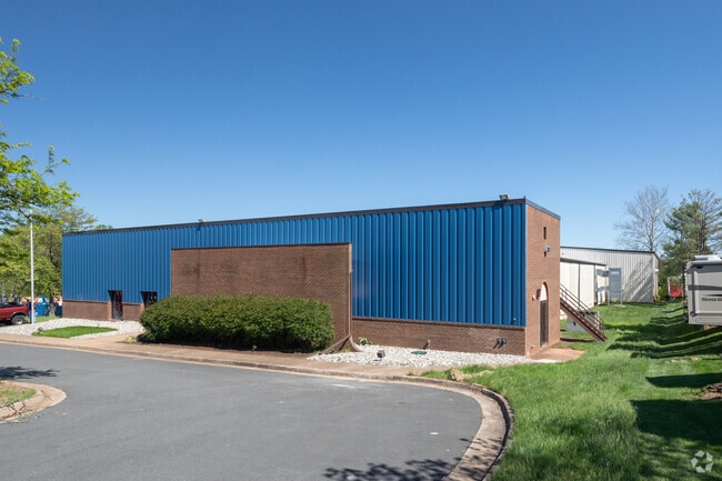
Property Record
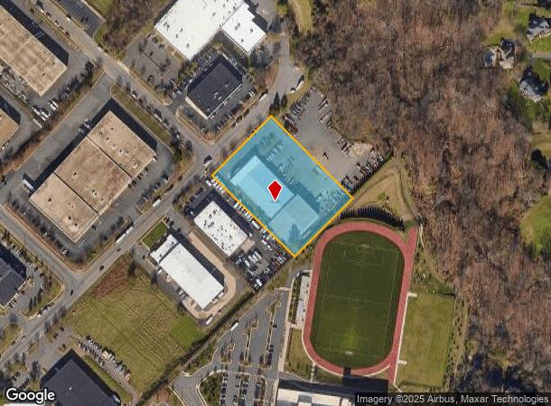
2881 Towerview Rd, Herndon, VA 20171

NEARBY LISTINGS FOR SALE OR LEASE
Property Detail
2881 Towerview Rd
Washington-Arlington-Alexandria, DC-VA-MD-WV
Dulles Industrial
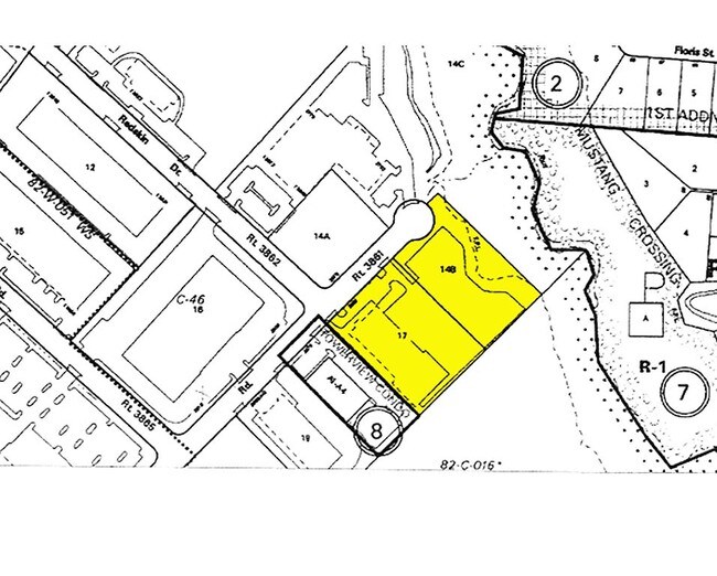
0242-01-0017
DULLES INDUSTRIAL LAND ASSOC PROP PCL 4 OF PT PCL B
Industrialgeneral
Fairfax
X
Virginia
51059C0120E
17
2024
2.50 AC
2025
Rt 28/Dulles South
482505
Washington, DC
37,612 SF
DEMOGRAPHICS near 2881 Towerview Rd
1 Mile
3 Mile
5 Mile
2024 Total Population
7,428
84,757
220,101
2029 Population
7,481
83,889
220,321
Pop Growth 2024-2029
+ 0.71%
(1.02%)
+ 0.10%
Average Age
39
37
38
2024 Total Households
2,544
29,562
79,295
HH Growth 2024-2029
+ 0.79%
(0.75%)
+ 0.10%
Median Household Inc
$162,968
$135,557
$139,614
Avg Household Size
2.80
2.80
2.70
2024 Avg HH Vehicles
2.00
2.00
2.00
Median Home Value
$733,919
$674,255
$649,829
Median Year Built
2003
1992
1988
Nearby Places
Map Layers
Map Styles
 Street
 Aerial
- Restaurants
- Banks
- Shops
- Fitness
- Groceries
PUBLIC TRANSPORTATION
AIRPORT
Washington Dulles International
DRIVE
WALK
Distance
Washington Dulles International
13 min
5.3 mi
Ronald Reagan Washington Ntl
DRIVE
WALK
Distance
Ronald Reagan Washington Ntl
45 min
29.5 mi
Freight Ports
Port of Baltimore
DRIVE
WALK
Distance
Port of Baltimore
84 min
61.4 mi
Nearby Properties
Address
Land Use
TOTAL SIZE
Lot Size
Zoning
Address
Land Use
TOTAL SIZE
Lot Size
Zoning
2,700,000 SF
7.51 AC
PDGI
Address
Land Use
TOTAL SIZE
Lot Size
Zoning
760,000 SF
2,461.49 AC
110
Address
Land Use
TOTAL SIZE
Lot Size
Zoning
1,030,157 SF
47.95 AC
550
Address
Land Use
TOTAL SIZE
Lot Size
Zoning
440,870 SF
47.69 AC
550
Address
Land Use
TOTAL SIZE
Lot Size
Zoning
520,500 SF
7.29 AC
400
Address
Land Use
TOTAL SIZE
Lot Size
Zoning
332,957 SF
12.68 AC
550
Address
Land Use
TOTAL SIZE
Lot Size
Zoning
425,073 SF
19.02 AC
330
Address
Land Use
TOTAL SIZE
Lot Size
Zoning
357,437 SF
3.76 AC
350
Address
Land Use
TOTAL SIZE
Lot Size
Zoning
429,038 SF
11.41 AC
400
Address
Land Use
TOTAL SIZE
Lot Size
Zoning
396,112 SF
15.92 AC
330
Address
Land Use
TOTAL SIZE
Lot Size
Zoning
490,340 SF
18.30 AC
320
Address
Land Use
TOTAL SIZE
Lot Size
Zoning
451,000 SF
7.50 AC
550
Address
Land Use
TOTAL SIZE
Lot Size
Zoning
491,841 SF
19.21 AC
320
Address
Land Use
TOTAL SIZE
Lot Size
Zoning
325,000 SF
22.05 AC
550
Address
Land Use
TOTAL SIZE
Lot Size
Zoning
519,708 SF
18.73 AC
316
Address
Land Use
TOTAL SIZE
Lot Size
Zoning
507,264 SF
10.44 AC
400
Address
Land Use
TOTAL SIZE
Lot Size
Zoning
423,718 SF
26.11 AC
596
Address
Land Use
TOTAL SIZE
Lot Size
Zoning
513,947 SF
22.23 AC
400
Address
Land Use
TOTAL SIZE
Lot Size
Zoning
408,315 SF
5.06 AC
400
Address
Land Use
TOTAL SIZE
Lot Size
Zoning
387,620 SF
6.01 AC
350
Address
Land Use
TOTAL SIZE
Lot Size
Zoning
492,219 SF
16.89 AC
330
Address
Land Use
TOTAL SIZE
Lot Size
Zoning
322,205 SF
6.91 AC
330
Address
Land Use
TOTAL SIZE
Lot Size
Zoning
452,626 SF
3.87 AC
400
Address
Land Use
TOTAL SIZE
Lot Size
Zoning
378,000 SF
9.06 AC
550
Address
Land Use
TOTAL SIZE
Lot Size
Zoning
453,939 SF
17.70 AC
320
Address
Land Use
TOTAL SIZE
Lot Size
Zoning
423,347 SF
15.49 AC
312
Address
Land Use
TOTAL SIZE
Lot Size
Zoning
282,193 SF
7.48 AC
400
Address
Land Use
TOTAL SIZE
Lot Size
Zoning
285,599 SF
8.01 AC
430
Address
Land Use
TOTAL SIZE
Lot Size
Zoning
365,468 SF
5.11 AC
400
The World's #1 Commercial Real Estate Marketplace
Connect with us
© 2025 CoStar Group
The information above has been obtained from sources believed reliable. While we do not doubt its accuracy we have not verified it and make no guarantee, warranty or representation about it. It is your responsibility to independently confirm its accuracy and completeness. Any projections, opinions, assumptions, or estimates used are for example only and do not represent the current or future performance of the property. The value of this transaction to you depends on tax and other factors which should be evaluated by your tax, financial, and legal advisors. You and your advisors should conduct a careful, independent investigation of the property to determine to your satisfaction the suitability of the property for your needs.